| |
|
24/02/2010 BLOM
will provide 3D high-resolution urban cartography in
XIRIO Online.
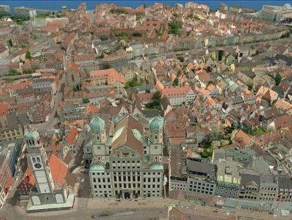
Intelia Consultores and BLOM, the multinacional company for cartography services and products, have reached an agreement to provide 3D high-resolution urban cartography in XIRIO Online. The deal includes all the 3D elevation models of cities worldwide that BLOM has in its portfolio.
The cartography provided by BLOM is high-resolution (1 m / pixel) and is updated in the years 2008, 2009 and 2010 depending on the city. Access to this new mapping in Xirio Online will be available in April and will begin providing access to over 250 cities worldwide, of which 30 are Spanish. The number of models, however, will increase throughout 2010, hoping to have more than 300 cities by year's end.
The quality and resolution of data provided by BLOM allows to have the best basis for simulations of radio coverage with wireless technology. The data's sources has an origin both vectorial as LIDAR technology, what allows achieving a very high precision in three dimensions (X, Y, Z) and modeling a scenario more alike to reality, identifying elements such as towers, gable roofs, courtyards, etc.

Along with the incorporation of this type of mapping, Xirio Online is incorporating more advanced calculation methods for network planning in urban environment (ITU-R Rec p.1411, COST231, Xia-Bertoni, Ray tracing, Okumura - Hata, Measurements adjusted Methods, ....). In this way, users can have the most advanced means on the market for the design of their networks.
Intelia Consultores and BLOM are convinced that the incorporation of high-resolution mapping in Xirio Online represents a qualitative leap in the accuracy of simulations of radio coverage and such a great opportunity for users to perform these calculations for a reduced price.

|
|
|