|
The toolbar in SharePlace is located at the top of the window and, depending on user's permissions, it will look similar to this:

In it there are the basic actions of the tool:
• Open results manager. It displays an ordered list called "Other results", which shows the results that have been published by other users and on which you have viewing permission. Open results manager. It displays an ordered list called "Other results", which shows the results that have been published by other users and on which you have viewing permission.
• Show information panel. Displays the information panel that shows the legend related to the results and other information. Show information panel. Displays the information panel that shows the legend related to the results and other information.
• Panel update. Refresh the information panels of the application and resets the viewer to its initial state. Panel update. Refresh the information panels of the application and resets the viewer to its initial state.
• Create new point of interest. A point of interest is a mark on the map at a location chosen by the user. It is defined by a name and some location characteristics, the coordinates, which can be entered manually, by selecting a location or by selecting a point in the viewer. Create new point of interest. A point of interest is a mark on the map at a location chosen by the user. It is defined by a name and some location characteristics, the coordinates, which can be entered manually, by selecting a location or by selecting a point in the viewer.
• Manage points of interest. This option allows creating new points, opening existing ones or deleting them. It also has a search filter by name. Manage points of interest. This option allows creating new points, opening existing ones or deleting them. It also has a search filter by name.
• Drag map. Moves the map area currently displayed in the visor. Drag map. Moves the map area currently displayed in the visor.
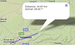
• Calculate distance. Find the distance between two points. The first click on the map fixes one of the extremes. The second click fixes the second end. From when the first point is set until the second is set, the horizontal bar below the viewer shows the distance and azimuth that are present at each moment as the cursor moves. When the segment is defined, a marker appears with the corresponding information. Calculate distance. Find the distance between two points. The first click on the map fixes one of the extremes. The second click fixes the second end. From when the first point is set until the second is set, the horizontal bar below the viewer shows the distance and azimuth that are present at each moment as the cursor moves. When the segment is defined, a marker appears with the corresponding information.
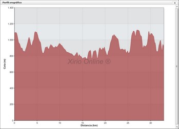
• Calculate profile. Shows the orographic profile between two points. The selection of the section to be displayed is done in the same way as in the "calculate distance" option. It also shows the distance and azimuth on the bottom bar until the second extreme is set. When the segment is defined, the profile is represented in a graph: Calculate profile. Shows the orographic profile between two points. The selection of the section to be displayed is done in the same way as in the "calculate distance" option. It also shows the distance and azimuth on the bottom bar until the second extreme is set. When the segment is defined, the profile is represented in a graph:
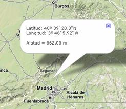
• Check altitude at a point. Read the altitude from the digital terrain model at the selected point on the map. Information is displayed in an informational marker. Check altitude at a point. Read the altitude from the digital terrain model at the selected point on the map. Information is displayed in an informational marker.
• Print. Allows the printing of screenshots of interest to the user on paper. Whatever the user wants to print, it must be shown in the viewer before clicking on this icon. If, for example, a coverage spot is not checked in the legend, it will not be displayed and therefore cannot be printed. Clicking on the icon opens a window that contains a duplicate of the Xirio viewer, with identical functionalities (zoom, arrows, map, satellite and relief modes ...), which will help the user to adjust and center the printing area. Print. Allows the printing of screenshots of interest to the user on paper. Whatever the user wants to print, it must be shown in the viewer before clicking on this icon. If, for example, a coverage spot is not checked in the legend, it will not be displayed and therefore cannot be printed. Clicking on the icon opens a window that contains a duplicate of the Xirio viewer, with identical functionalities (zoom, arrows, map, satellite and relief modes ...), which will help the user to adjust and center the printing area.
• Search Address. Allows you to search for addresses, terms, coordinates, etc. displaying a list of possible search results. Once the user selects the most appropriate search result, the cartographic viewer will indicate the selected geographic point with a Google Maps marker, using its search engine. For more information, consult the Google Maps help manual. Search Address. Allows you to search for addresses, terms, coordinates, etc. displaying a list of possible search results. Once the user selects the most appropriate search result, the cartographic viewer will indicate the selected geographic point with a Google Maps marker, using its search engine. For more information, consult the Google Maps help manual.
| 


