|
|
<< Pulse para mostrar la Tabla de Contenidos >> CARTOGRAPHY LAYERS |


|
|
|
<< Pulse para mostrar la Tabla de Contenidos >> CARTOGRAPHY LAYERS |
|
|
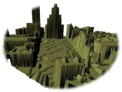
To perform a study calculation, Xirio requires detailed information of the terrain on which calculation is running. At least, it is necessary the altimetric heights information of the terrain, although in some calculations it is also advisable to have information about the use of the land on which calculation is perforemed. There are four types of cartography layers in Xirio: •DTM or altimetry layer. It is a layer of elevation in which elements such as buildings, roads and vegetation have been eliminated digitally. The digital terrain model assigns an altimeter height above sea level to each pixel. This type of cartography is suitable for broadcasting network planning in which urban environments are usually modeled by adding additional clutter losses or by different thresholds depending on the type of environment. It provides the highest resolution and precision available on the market for large areas in Europe.
•DBM or elevation. It provides elevation information at each point in urban environments with high resolution. This model assigns to each pixel an elevation value by combining the altimetric dimension with buildings height. The DBM therefore includes an DTM plus buildings height and is suitable for calculations in cities.
•DSM (Digital Surface Model). It includes a DTM lus the height of different elements such as buildings, trees, infrastructures, etc. This type of cartography has a wider extension than the DBM ince it includes urban and rural environments. This makes it suitable in order to analyze obstruction in fixed services radio-links in microwave bands, as well as of other high frequency technologies.
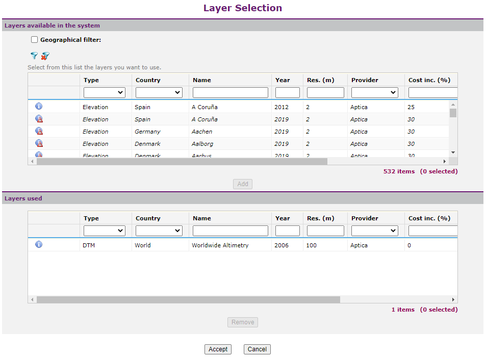
•Morphographic layer. This is a raster layer in which each pixel belongs to a category of land use. This category has a number of attributes that can modify the radio signal present at a point either by the increase in height (eg presence of a forest), additional losses (of deterministic nature and that come from a measurement campaign checked with the prediction results), terrain type (according to ITU-R Rec. 1546) and terrain type according to a wider categorization, and characterized by permittivity and conductivity values. •Administrative layer. It is a vector layer, which contains a set of polygons representing geographic regions characterized by a name and a number of inhabitants. Each administrative layer has different granularity, being able to find administrative layers at provincial, municipal or population nucleus level. These layers are used to obtain coverage statistics, interference statistics, etc. In Xirio, these layers can be of various types: oExclusively administrative: they include only entities with an associated surface area (in km2) and a total population (in inhabitants) that is equally distributed over the entire surface area. oAdministrative with demography: similar to the previous ones, but they also include a raster layer that specifies the population density (in inhabitants/km2) in each pixel, according to its resolution. oRoads: include lines with associated distances (in km). oPoints: include geo-referenced points. oMasks: include contours, which can be applied both for statistical calculations and to delimit the areas in which to display a result. CARTOGRAPHY SELECTION In the cartography selection window, the user can search Xirio's available cartography and easily add it to the study.
There is the possibility of filtering layers in the system by the following criteria: •Layer Type: DTM, DBM or Morfographic. •Layer Name. The layers that contain the specified name will be selected. •Calculation Area. The layers whose surface intersects in whole or in part with the rectangle that will limit the calculation area of study will be selected. •Regions. To filter by region, first, the user must select a continent and a country. Layers corresponding to that region will be selected. CARTOGRAPHIC LAYER INFORMATION From this window, the user can access more complete information for each layer by selecting the corresponding option
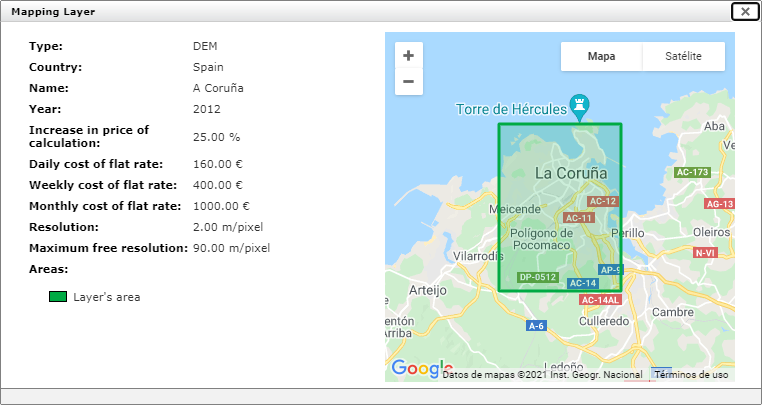
This dialog shows all available layer information: •Name. •Type: DTM, DBM or Morfographic. •Provider. •Increase in calculation price. Percentage that indicates the layer cost in calculations. It is only applied in the case of making payment calculations (exempt Xirio Online). •Resolution. Is the layer resolution. Indicates the size of the selected raster layer pixels. For example, in a layer of 100 m resolution, the information about the terrain elevation will be each 100 m. • Maximum free resolution. Sets the maximum resolution that a free calculation with this layer can be performed (not in Xirio Online because all calculations are madre in high resolution). •Description. In case of morphographic layers, the information icon is with another icon which allows to access to the morphographic dictionary. An editing page will open for this dictionary:
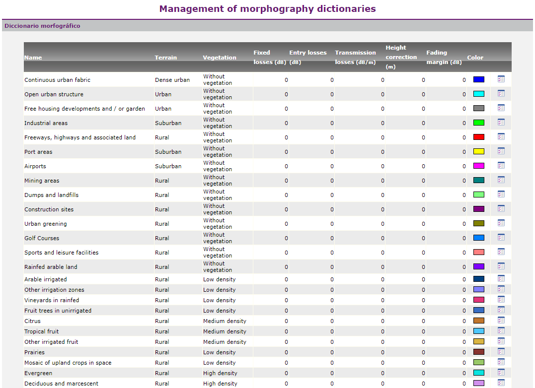
The attributes of the morphographic layer are entered through this dictionary. Each category of the terrain can be associated with: •Name. •Terrain (sea, forest, urban, open-space, etc.), which will determine formulas to applied according to ITU-R Rec. 1546. •Vegetación (high/medium/low or no vegetation density), which will also influence the calculation method. •Clutter losses (in dB). •Entry losses (in dB). Used in simulations with the Synapse calculation method. •Transmission losses (in dB). Used in simulations with the Synapse calculation method. •Height Correction (height in meters on the digital terrain model). •Fading margin (in dB). It is used to override the fading margin value set in the calculation method. It parameterizes the distribution of the signal against time and locations, in those cases where the reception threshold considers only medium signal values (for 50% of the time and for 50% of the locations). •Color assigned.
The algorithm takes into account all these attributes, adding precision to calculation. |