|
|
<< Pulse para mostrar la Tabla de Contenidos >> CALCAULTION FLAT RATE |


|
|
|
<< Pulse para mostrar la Tabla de Contenidos >> CALCAULTION FLAT RATE |
|
|
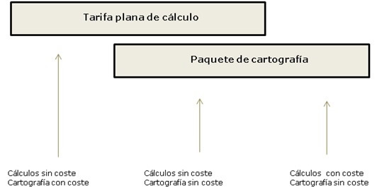
Xirio offers a basic calculation rate of different duration (daily, weekly or 30 days) that allows the realization of an unlimited number of high resolution calculations during the contracted time: •Daily basic rate. It allows high resolution calculations for a day from the purchase. •Weekly basic rate. It allows high resolution calculations for a week from the purchase. •30 days basic rate. It allows high resolution calculations for 30 days from the purchase.
The basic rate includes: •Free high resolution calculations. The cost associated with all studies calculations conducted during the term of the fee is included in it, regardless of resolution. •Free cartography. These rates include the use of free maps available at Xirio. If you wish to use the cartography offered by Xirio, the price must be paid.
Additionally, if you want to use payment cartography continuously, you can purchase cartography packages lasting a week or 30 days from the date of acquisition. It is possible to consult advantages of using payment cartography. The validity of cartography package is independent of the basic calculation rate one, so if the cartography package is acquired after basic calculation rate, the user can continue using the cartography package after the expiration of basic calculation rate. In that case the user would have to pay for the cost of calculations. The basic calculation rate can be extended or renewed.
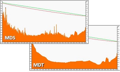
CARTOGRAPHY PROVIDERS Xirio has a wide cartography range guaranteeing practically global coverage all over the planet. This cartography comes from official sources and is provided by different providers worldwide including APTICA. The access to each cartography depends on different commercial agreements established with the suppliers predominating two models: •Local Cartography: This cartography is stored on Xirio's own servers, so access to it is immediate. •Remote Cartography: This cartography is stored in servers of the cartographic providers, so that Xirio accesses it in real time and uses it. This gives him access to cartography by slightly increasing studies calculation time. CARTOGRAPHY SELECTION It is a layer of elevation in which elements such as buildings, roads and vegetation have been eliminated digitally. The digital terrain model assigns an altimeter height above sea level to each pixel. This type of cartography is suitable for broadcasting network planning in which urban environments are usually modeled by adding additional clutter losses or by different thresholds depending on the type of environment. It provides the highest resolution and precision available on the market for large areas in Europe.
It provides elevation information at each point in urban environments with high resolution. This model assigns to each pixel an elevation value by combining the altimetric dimension with buildings height. The DBM therefore includes an DTM plus buildings height and is suitable for calculations in cities.
It includes a DTM lus the height of different elements such as buildings, trees, infrastructures, etc. This type of cartography has a wider extension than the DBM ince it includes urban and rural environments. This makes it suitable in order to analyze obstruction in fixed services radio-links in microwave bands, as well as of other high frequency technologies.
|