|
|
<< Pulse para mostrar la Tabla de Contenidos >> ITU-R REC. P.452 |


|
|
|
<< Pulse para mostrar la Tabla de Contenidos >> ITU-R REC. P.452 |
|
|
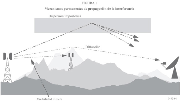
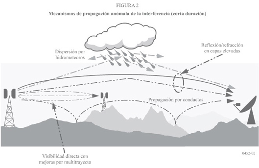
DESCRIPTION The ITU-R Recommendation P.452 [1] contains a prediction method for the evaluation of interference between stations on the surface of the Earth at frequencies above about 0.1 GHz, taking into consideration both clear-air and hydrometeor scattering interference mechanisms The method includes the influence of different propagation mechanisms, with different application ranges regarding path distance or probability. The model is restricted to: •f: 0,1 to 50 [GHz] •d: up to 10000 [km] •p: 0,001-50 [%] The method is briefly described in the next Section. The calculations are not described in full detail, because of their complexity and the worldwide availability of ITU-R Recommendations. The complete calculations details are available in [1]. DEVELOPMENT Interference may arise through a range of propagation mechanisms whose individual dominance depends on climate, radio frequency, time percentage of interest, distance and path topography. At any time a single mechanism or more than one may be present. The principal interference propagation mechanisms considered by ITU-R Rec. 452 are described bellow, with references to Fig. 1 and 2 [1], which graphically present the long-term and short-term mechanisms. •Line-of-sight (Fig. 1): The most straightforward interference propagation situation is when a line of sight transmission path exists under normal (i.e. well mixed) atmospheric conditions. However, an additional complexity can come into play when subpath diffraction causes a slight increase in signal level above that normally expected. Also, on all but the shortest paths (i.e. paths longer than about 5 km) signal levels can often be significantly enhanced for short periods of time by multipath and focusing effects resulting from atmospheric stratification (see Fig. 2). •Diffraction (Fig. 1): Beyond line-of-sight (LoS) and under normal conditions, diffraction effects generally dominate wherever significant signal levels are to be found. For services where anomalous short-term problems are not important, the accuracy to which diffraction can be modeled generally determines the density of systems that can be achieved. The diffraction prediction capability must be such to cover smooth Earth, discrete obstacles and irregular (unstructured) terrain situations. •Tropospheric scatter (Fig. 1): This mechanism defines the “background” interference level for longer paths (e.g. more than 100-150 km) where diffraction field becomes very weak. However, except for a few special cases involving sensitive earth stations or very high power interferers (e.g. radar systems), interference via troposcatter will be at too low a level to be significant.
•Surface ducting propagation (Fig. 2): This is the most important short-term interference mechanism over water and in flat coastal land areas, and can give rise to high signal levels over long distances (more than 500 km over the sea). Such signals can exceed the equivalent “free space” level under certain conditions. •Elevated layer reflection and refraction (Fig. 2): The treatment of reflection and/or refraction from layers at heights up to a few hundred metres is of major importance as these mechanisms enable signals to overcome the diffraction loss of the terrain very effectively under favourable path geometry situations. Again the impact can be significant over quite long distances (up to 250-300 km). •Hydrometeor scattering (Fig. 2): Hydrometeor scattering can be a potential source of interference between terrestrial link transmitters and earth stations because it may act virtually omnidirectionally, and can therefore have an impact off the great circle interference path. However, interfering signal levels are quite low and do not usually represent a significant problem.
The Recommendation includes separate methods for clear-air and hydrometeor-scattering interference.
Clear-air interference The following input data are required: •Frequency f [GHz]. •Percentage of time for which the calculated basic transmission loss is not exceeded, in the average year (p) or in the average worst-month (pwm). •Geographical coordinates of both stations and antenna center heights above ground level and mean sea level. •Antenna gains Gt, Gr (dBi) in the horizon direction along the great-circle interference path for both stations. •Type of terrain: Coastal land, inland or sea. •Radiometeorological data as: oΔN (N-units/km), the average radio-refractive index lapse-rate through the lowest 1 km of the atmosphere. oß0 (%), the time percentage for which refractive index lapse-rates exceeding 100 N-units/km can be expected in the first 100 m of the lower atmosphere, used to estimate the relative incidence of fully developed anomalous propagation at the latitude under consideration. oN0 (N-units), sea-level surface refractivity. Basic propagation loss is evaluated with different methods: •Line-of-sight propagation, which includes free-space propagation, absorption by atmospheric gases and a provision for short-term effects: Multipath and focusing can reduce the basic propagation loss for short periods of time. •Diffraction. The diffraction loss is calculated for all paths using a hybrid method based on the Deygout model and an empirical correction. This method provides an estimate of diffraction loss for all types of paths, including over-sea or over-inland or coastal land, and irrespective of whether the land is smooth or rough. •Tropospheric scattering. At time percentages much below 50%, it is difficult to separate the true tropospheric scattering mode from other secondary propagation phenomena which give rise to similar propagation effects. The “tropospheric scatter” model adopted in this Recommendation is therefore an empirical generalization of the tropospheric scatter concept which also embraces these secondary propagation effects. This allows a continuous consistent prediction of basic transmission loss over the range of time percentages p from 0.001% to 50%, thus linking the ducting and layer reflection model at short time percentages with the true “scattering mode” appropriate to the weak residual field exceeded for the largest time percentage. This prediction model of tropospheric dispersion has been derived for interference prediction purposes and is not appropriate for calculation of propagation conditions above 50% of time affecting the performance aspects of trans-horizon radio relay systems. •Ducting and layer reflection, phenomena that give rise to anomalously high levels of signal. •Clutter losses. Considerable benefit, in terms of protection from interference, can be derived from the additional diffraction losses available to antennas which are imbedded in local ground clutter (buildings, vegetation etc.). This procedure allows for the addition of such clutter losses at either or both ends of the path in situations where the clutter scenario is known. The basic propagation loss is calculated as a combination of five calculated terms. Additionally, the transmission loss can be calculated by taking into account the antenna gains for the paths. A procedure is provided that considers the radio horizon elevation for non-LOS paths. REFERENCES [1] ITU-R Recommendation P.452-14, "Prediction procedure for the evaluation of interference between stations on the surface of the Earth at frequencies above about 0.1 GHz", ITU, Geneva, Switzerland, 2009. |