|
|
<< Pulse para mostrar la Tabla de Contenidos >> CALCULATION METHOD |


|
|
|
<< Pulse para mostrar la Tabla de Contenidos >> CALCULATION METHOD |
|
|
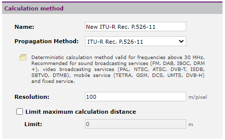
The calculation method is the procedure that is going to be used to estimate the propagation of electromagnetic waves through space. You must decide which simulation model you want to use in each case depending on the environment in which the network is being deployed, the technology used, the working frequency bands and the quality of the cartographic information available to model the terrain. When creating a new study, Xirio proposes by default the most suitable method for the calculation to be carried out. Otherwise the calculation method can be created from scratch or through the catalog. In this case, a copy of the selected catalog item will be uploaded, so that the item will not be modified. A calculation method is characterized by different parameters. Some of them are common to all propagation methods, other basic parameters are common for most calculation methods and others are more specific depending on the selected propagation method (such as Rec. ITU-R P.526, indoor or Synapse). There is also an editable calculation method that allows a customization of the propagation model.
The common parameters of all propagation methods are: •Name •Resolution. Resolution at which the calculations will be performed. The usual thing is to choose the same resolution of the cartography used. However, in some cases it is useful to start working with worse resolutions, to obtain a quick and approximate calculation, then moving on to obtaining more accurate results. •Limit maximum calculation distance, in meters Common parameters for most calculation methods.
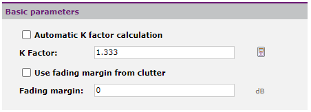
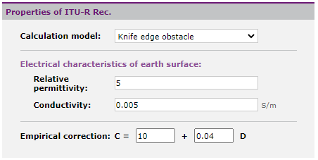
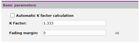
•Automatic calculation of factor K. When this option is activated, it is not necessary to configure the factor K in the dialog since it will be evaluated automatically during the calculation. •K Factor. Factor of earth curvature in the geographical area of the earth in which the calculations are made, depends on the tropospheric refractive index. It is possible to tell the tool to calculate the K Factor automatically based on the geographical position of the radioelectric elements determined in each study. With the option •Fading margin. Only applicable in simulations of mobile service. It parameterizes the distribution of the signal against time and locations, in those cases where the reception threshold only contemplates medium signal values (for 50% of the time and for 50% of the locations). It is obtained through a standard deviation as a function of the frequency and a statistical distribution of the Log-Normal or Rayleigh type. The final results be the signal level exceeded during the percentage of time and/or locations used to calculate this "Fading Margin". •Use fading margin from clutter. The morphographic dictionary can set a different fading margin value for each type of clutter. Activating this option, that value will be used in the calculations and the fading margin defined in the calculation method will be ignored. REC. ITU-R P.526-11 PROPERTIES Deterministic method based on diffraction. Valid for frequencies greater than 30 MHz. Used in all radioelectric services in rural and mixed environments as long as medium or high resolution cartography is available.
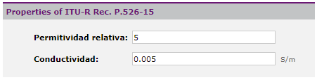
•Calculation model: Allows you to select between the different models offered by the ITU-R P.526 recommendation: smooth earth, knife edge obstacles and rounded obstacles. There is also an "automatic" option that evaluates the most suitable model for the calculation environment. •Relative permittivity: The relative permittivity to use with the smooth earth model. •Conductivity: The conductivity to use with the smooth ground model. •Empirical correction: It allows modifying the expression proposed by recommendation ITU-R P.526 for the case of the knife edge model. REC. ITU-R P.526-15 PROPERTIES Deterministic method based on diffraction. Valid for frequencies greater than 30 MHz. Used in all radioelectric services in rural and mixed environments as long as medium or high resolution cartography is available.
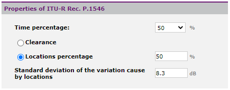
•Relative permittivity: The relative permittivity to use with the smooth earth model. •Conductivity: The conductivity to use with the smooth ground model. REC. ITU-R P.1546 PROPERTIES Empirical method for the frequency range from 30 MHz to 1 GHz. Valid in rural environments for any radio service, but especially recommended for sound and audiovisual broadcasting when precise mapping is not available or at distances greater than 100 km.
•Time Percentage: The required time percentage in the range of 1% to 50%. •Clearance: Use the method indicated in the recommendation when information is available on the terrain clearance angle. This clearance is automatically evaluated during the calculation. •Locations percentage: The objective of percentage of locations considering the variations due to the occupation of the land in the vicinity. •Standard deviation of the variation with locations: Standard deviation to be used when the desired location size is different than 50% OKUMURA-HATA PROPERTIES Empirical method valid in the range 150 MHz to 2 GHz. Recommended for mobile and broadband access services in rural and urban environments when high resolution mapping is not available. The properties of the modulated Okumura-Hata method are the same.
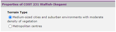
•Area: urban, suburban or rural. •City size: small or big. REC. ITU-R P.1411 AND COST 231 PROPERTIES Deterministic methods valid in the frequency range 300 MHz to 100 GHz and 800 MHz to 2 GHz, respectively. Recommended for urban environments in mobile services and broadband access. Require urban mapping with building information (DEM).
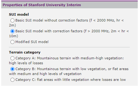
•Environment type: medium-sized cities or metropolitan centers. STANFORD UNIVERSITY INTERIM PROPERTIES Empirical method valid for frequencies below 11 GHz. Recommended for mobile and broadband access services (especially WiMAX) when urban mapping with buildings (DEM) is not available.
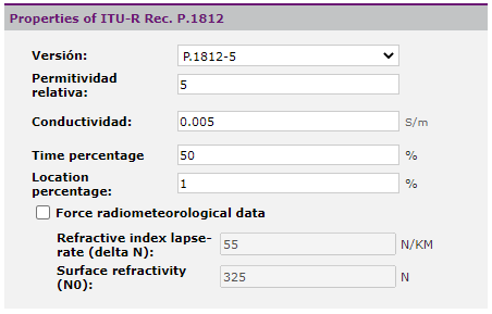
•SUI model: It allows selecting the appropriate SUI model for the calculation. •Terrain category: Depending on the type of terrain and the surrounding vegetation REC. ITU-R P.1812 PROPERTIES Deterministic method valid in the frequency range 30 MHz to 3 GHz. Used in rural and mixed environments for all radio services, and especially broadcasting, provided that medium or high resolution cartography is available.
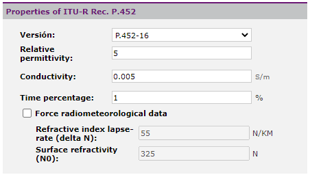
•Version: Version of Recommendation UIT-R P.1812 •Relative permittivity: The relative permittivity to use with the smooth earth model. •Conductivity: The conductivity to use with the smooth ground model. •Time Percentage: The required time percentage in the range of 1% to 50%. •Locations percentage: The target percentage of locations considering the variations due to land occupation in the vicinity. •Force radiometeorological data: If this option is activated, the meteorological data indicated in this window will be used during the calculation. Otherwise they are automatically evaluated during simulations. •Refractive index lapse-rate (delta N): the average gradient of the radioelectric refractive index along the first km of the atmosphere. •Surface refractivity (N0): refractivity of the surface at sea level REC. ITU-R P.452 PROPERTIES Deterministic calculation method valid in the frequency range from 700 MHz to 50 GHz. Especially recommended for the calculation of interference in radio links in the fixed service.
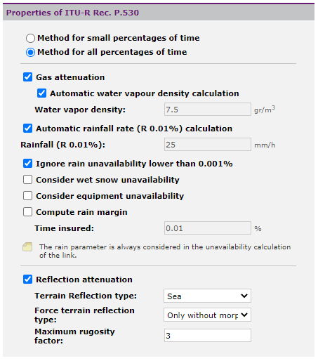
•Version: Version of Recommendation UIT-R P.452 •Relative permittivity: The relative permittivity to use with the smooth earth model. •Conductivity: The conductivity to use with the smooth ground model. •Time Percentage: The required time percentage in the range of 1% to 50%. •Force radiometeorological data: If this option is activated, the meteorological data indicated in this window will be used during the calculation. Otherwise they are automatically evaluated during simulations. •Refractive index lapse-rate (delta N): the average gradient of the radioelectric refractive index along the first km of the atmosphere. •Surface refractivity (N0): refractivity of the surface at sea level REC. ITU-R P.530 PROPERTIES Deterministic calculation method valid for frequencies greater than 30 MHz. It incorporates the feasibility analysis of digital radio links of the fixed service.
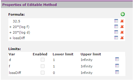
•Gas attenuation. It can be set manually or configured to have the tool derive the water vapor density value from the corresponding recommendation based on the end coordinates. The calculator button •Rainfall. It can be set manually or configured to have the tool obtain the rainfall value of the corresponding recommendation based on the coordinates of the extremes. The calculator button •Ignore rain unavailability lower than 0.001%. Rec. UIT-R P.530 is not valid for calculated unavailability values less than 0.001% of the time. The user can thus choose to eliminate this calculation in these cases. •Compute rain margin. In the event that this option is activated, in the digital hop reports a margin for rain will be obtained that will determine, in continuous rain conditions, the margin available at reception. This margin is informative since it will not be used for the calculation of quality and unavailability. •Reflection attenuation. In the event that this option is activated, the calculation will consider the possible reflections originating from the path. The user may specify the type of path where the reflection occurs or may indicate that the tool automatically obtains it from the morfographic layer in the case that one has been established in the study. Likewise, you can set the "Maximum rugosity factor" to consider that a reflection occurs. A typical value for this parameter is 3. Calculation method configurable by the user, in which it is possible to define the basic loss associated with the propagation of the signal through an expression configured manually by the user. In the terms of said expression, terms involving distance (Km), frequency (MHz), transmitter height (m), receiver height (m), effective transmitter height (m) and diffraction losses (dB).
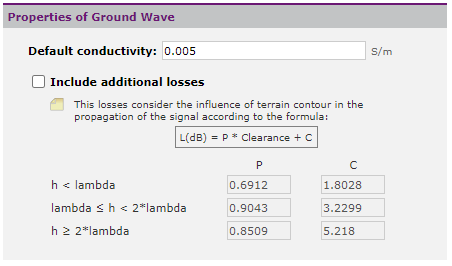
With the option The addends are of the form: Constant * Operator1(Variable1)^Exponent1 * Operator2(Variable2)^Exponent2 Operators can be: •Null: there is no effect on the variable •Logarithm •Power The variables that can be used are: •Distance (km) •Frequency (MHz) •Transmitter height (m) •Receiver height (m) •Transmitter effective height (m) •Diffraction losses Also the result of applying the operator on the variable can be raised to an additional exponent. SURFACE CURVES PROPERTIES Ground wave propagation calculation method. Valid for frequencies below 30 MHz. It is recommended to use morphographic mapping of ground conductivities.
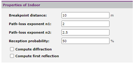
•Default conductivity: In the case of not having a morphographic layer with information on conductivities and permittivities of the soil, it is possible to define a default value. •Include additional losses. The Surface Curves calculation method does not behave correctly in very mountainous terrain. By activating this option it is possible to define a correction depending on the clearance. Empirical 2.5D calculation method for indoor propagation prediction. Compatible with indoor-outdoor, outdoor-indoor propagation scenarios and between different floors.
•Breakpoint distance: Distance that separates the two propagation zones that are distinguished in the model. Below this distance, it is considered that the walls and ceilings do not affect the propagation of the signal and the exponent n1 of variation with distance is used. Above this distance we have the opposite case and the exponent n2 is used. •Path-loss n1 exponent: Variation exponent for distances smaller than the break distance. •Path-loss n2 exponent: Variation exponent for distances greater than the break distance. •Reception probability: for radiating cable calculations. •Compute diffraction: When this option is active, an additional component of diffraction in corners is evaluated during the calculation. •Compute first reflection: When this option is active, an additional component of walls reflection is evaluated during the calculation. REC. ITU-R P.528 PROPERTIES Valid empirical calculation method in the frequency range 125 MHz to 15.5 GHz. Recommended for aeronautical mobile and aeronautical radionavigation services using the VHF, UHF and centimeter wave bands.
•Time Percentage: The required time percentage in the range of 1% to 50%. REC. ITU-R P.1147 PROPERTIES Empirical prediction method for the frequency range from about 150 to 1700 kHz, for path lengths from 50 to 12000 km.
•Date: Day and month. •Time: Hours, minutes and the reference to UTC. •Sunspot number: Also known as Wolf number, it is a quantity that measures the number and size of sun spots. •ITU Region: According to the following map. REC. ITU-R P.533 PROPERTIES Empirical method for predicting available frequencies, signal levels, and predicted reliability for HF analog and digital modulation systems.
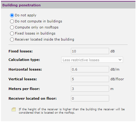
•Date: Day and month. •Time: Hours, minutes and the reference to UTC. •Sunspot number: Also known as Wolf number, it is a quantity that measures the number and size of sun spots. •Environment noise: City, residential, rural, quiet rural, quiet and noisy. BUILDING PENETRATION PROPERTIES Parameters common to various calculation methods for evaluating building penetration losses. It allows configuring both the vertical penetration from the building roof and the horizontal penetration from the street.
•Calculation configuration: The user can select one of the following configuration options: oDo not apply oDo not compute in buildings: The coverage spot only shows data in the street. oCompute only on rooftops: No result is displayed on streets. In addition, the receiver is considered to be on the roof of the building. oFixed losses in buildings: Only a fixed value of losses in buildings that is applied to the result on the roof is considered. oReceiver located inside the building: Horizontal and / or vertical losses will be considered depending on the configuration of this dialog. •Fixed losses: fixed losses that are always considered for the last two calculation configurations. •Calculation type: When it is considered that the receiver is located inside the building, three types of penetration calculation can be performed: oOnly vertical losses: From the roof. To the fixed losses, losses are added by the number of floors crossed. oOnly horizontal losses: From the street. Fixed losses and vertical losses are applied to the signal present in the street depending on the meters penetrated. oLess restrictive losses: The smaller losses between horizontal and vertical. •Horizontal losses: Losses per meter traveled indoors. •Vertical losses: Losses per floor crossed. •Meters per floor: Height of each floor, to evaluate the number of floors crossed during the calculation •Receiver located on floor: To evaluate the floors crossed, it is possible to locate the receiver on a floor other than street level. In the event that the building does not have enough floors, the receiver is considered to be located on the roof. For details about the properties and how to configure the Synapse propagation model in Xirio, please go to the Configuring Synapse page. |